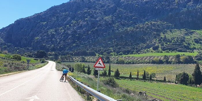
The Axarquia region to the East of Malaga is a beautifully rugged area of hills, mountains, ravines and valleys. For cyclists, this terrain provides a range of climbs to be conquered many of which are utilised in the thriving local race scene. There are many stretches of challenging ascents, but we have selected what local cyclists believe are the best.
Fuente de la Reina/ Puerto del León
The climb to Fuente de la Reina starts in the outskirts of Malaga. The hustle and bustle of a busy city and noise of traffic is soon replaced by peace and tranquillity. The only sound you may hear will be the amplified sound of your breathing as you tackle the steady gradient of this beautiful climb. Along the way are a string of interesting BBQ restaurants. These are busy at the weekend with Malaguenos enjoying the pine scented air of the Montes de Malaga Natural Park. The road is surprisingly quiet despite the proximity to the busy city below. Most of the ascent is in fresh pine forests offering amazing glimpses of the city shrinking below as you climb upwards. The ascent from Malaga is approximately 15 kms and has an average gradient of 6.5. At the peak you are just over 900 meters above sea level. The fountains themselves are near the top of the climb at the Puerto de Leon. A spring has remained here from time immemorial. However, it is thought to be named after Queen Isabelle who drank here in 1492 during the Reconquest. Cyclists can also replenish their Bidons here with spring water.
There is café near there fountains for basic food and coffee or you could press on to Hotel Galway a few kms over the top of the Puerto for more substantial fare. For cyclists wishing to compete there is the annual Subida de la Fuente de la Reina at the end of September. This is part of a hill climb series in the Malaga area.
Puerto del Sol
This pass is considered by some local riders to be the greatest climb in the Axarquia region. It is situated to the north of the province and starts a few kilometres from the village of Periana. This is a remote and rugged area populated by hardy farmers, goats and eagles. During the ascent be vigilant for goat herds supervised by wily dogs keeping things mostly under control. The climb offers stunning views back down to the coast and, on clear days, over to the Moroccan coast. The road itself winds upwards into the rugged Sierra for 6.5 kms at an average of 7 percent. However, some of the switchbacks have gradients up to 16 percent and can be a tough test. The Puerto Del Sol is the final climb in the annual Pirineo Costa Del Sol race. This crosses the Sierra via three different passes. It is not to be missed if you are in the area in late May.
You crest the peak at 1078 meters above sea level before a relatively brief descent down to the village of Alfarnate. The climate is notably cooler here and olive and almond trees give way to cherries and pears. The mountain scenery surrounding Alfarnate is exceptional. It can be appreciated from one of the little cafes in the Moorish village. A very old Venta with a museum lays 2 kms outside of the village. The venta is famous for being a bandit’s hideaway in earlier times. It can sometimes be closed so best to check the opening times before starting out.
The Ruta de Cabra
The Cabra is strictly speaking outside of the Axarquia region but is easily reachable by the N340 coast road. This links the resorts of the coast to the beginning of the climb at Almunecar. It is a long ascent into a rugged landscape with craggy pinnacles and bubbling streams.
The busy resort town of Almunecar is the point that you leave the coast and commence the incline of the climb of the Ruta de Cabra. Initially the road heads away from the town’s outskirts into mango and avocado groves along the Rio Verde. You then cycle under the soaring bridge of the A7 coastal motorway before reaching the villages of Jete and Otivar. Both towns offer places for refreshments. This is a sensible option as places are limited for the next section of the ride. Soon you will be ascending in earnest up a spiralling road into the Sierra Almijara. The climb is in two sections. The first is 18km of steady 5 percent gradient before a short descent. The second is a further uphill section of 5 kms at 4 percent gradient. On the route you have magnificent views of the sea way below, some beautiful rock formations and a short tunnel cut through the mountain rock. The official climb goes to the Mirador. The more adventurous may wish to continue to ride through the mountains completing a long loop via Zafarraya.
Boquete de Zafarraya
This is a climb on most cyclists to do list and for good reason. The boquette itself is visible for miles around when looking up to the inland Sierras from the Torre Del Mar and Velez Malaga area. At the summit stand 2 sentinel rocks on either side of the road. It is a beautiful example of glacial geology. As you ascend from Puente De Manuel there are sweeping views over to the village and campo of Alcaucin in the foothills of Mount Maroma. On the left the ruins of a Moorish castle named Zalia can be spotted just above the road. The gradient is a reasonably constant 5.8 percent average. The hardest part of the climb is psychological. The pass is always visible and appears interminably above you. The twisting road ahead on the mountain side plays mind games giving the impression that the road is longer and harder. At the top as you pass through the two rocks you enter the province of Granada and the small town of Venta de Zafarraya. As you look back you can look down to the sea way in the distance! Overall, the climb is 12 kilometres and the altitude at the top is 906 meters.